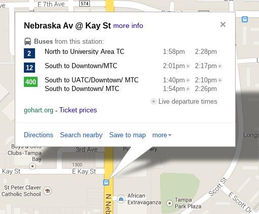
HART continues to set the
transit agency bar higher as a trendsetting innovator by being the first in
Florida to make real-time trip updates available on Google Maps starting
October 10.
Google Maps allows riders to
quickly and accurately plan transit trips from one location to another. That
makes public transportation more user-friendly for new riders and gives
seasoned, experienced riders a tool to help them get to their destinations in
new, more efficient ways. Trip updates represent any changes in the
timetables for predicted arrivals for stops along the route.
- HART is the
first transit agency in Florida to publish real-time trip updates via
Google Maps, which is available on desktop and mobile devices in more
than 40 different languages and in a format compatible with screen
readers for the visually impaired. Trip updates can also provide for
more complex scenarios where trips are canceled, added to the schedule,
or even re-routed.
- Instead of
sorting through timetables, riders simply enter the date and their
desired time of arrival or departure. The trip planner automatically
maps available routes and displays the travel time and number of
transfers for each option, so riders can pick their preferred
route.
- Google Maps
also includes transfers between different transit agencies in
overlapping service areas for those who have made their schedule
information available to Google. Detailed information on how to get to
or from a transit station on foot is shown for transit results along
with affording users the option to view aerial imagery, street level
images via Street View, and additional local information such as
business reviews.
HART continues to demonstrate
building awareness of public transit in Florida through our efforts of
exposing greater transit information to get riders to where they need to go.
HART's newest innovation comes hot on the heels of its high-tech OneBusAway
Tampa smart phone app, which provides instant access to real-time bus arrival
information to answer the question "Where is my bus?"
Google Maps, on the other hand, is a highly efficient trip
planning solution that solves the challenge of "What is the quickest way
to get where I want to go using the public transit system?" The two
applications work hand-in-hand to save riders valuable time and make their
travel easier and more enjoyable.
|


No comments:
Post a Comment
Comments to this blog are moderated by HART staff. Constructive comments are welcome; any obscene, threatening, or otherwise inappropriate comments will be deleted before posting. Questions about specific service ("is my bus on time?") cannot be answered here, and should be directed to the HARTinfo Line at (813) 254-HART (4278). General questions may be addressed in future posts.